Ocean Winds announced the start of underwater surveys for its Golden State Wind Project
A second company has been green-lighted to start sound wave surveys of the ocean floor in advance of installing offshore floating wind energy turbines.
Ocean Winds, one of three companies that won leases in the so-called Morro Bay Call Area, 20-30 miles off the Coast of San Simeon and totaling nearly 400 square miles, announced the start of underwater surveys for its Golden State Wind Project (GSW).
GSW Spokeswoman Erica Crawford said in a news release that GSW is a 50/50 partnership between Ocean Wind and the Canadian Pension Plan or CPP Investments.
CPP Investments is to Canada what Social Security is to the U.S., collecting, investing, and managing the pension fund for some 22 million Canadian workers and private businesses for the past 25 years, and is currently valued at some$632 billion.
The GSW Project is 22 miles offshore and 53 miles northwest of Morro Bay, its nearest port.
Crawford said that GSW, as of Monday June 17, “has received all required permits and approvals to commence geophysical survey activities in the federally regulated waters off the Coast of Central California, and will begin those surveys on July 2.”
GSW joins Equinor and its Atlas Wind Project in starting the underwater surveys of the seafloor in federal waters, where the Call Area is located.
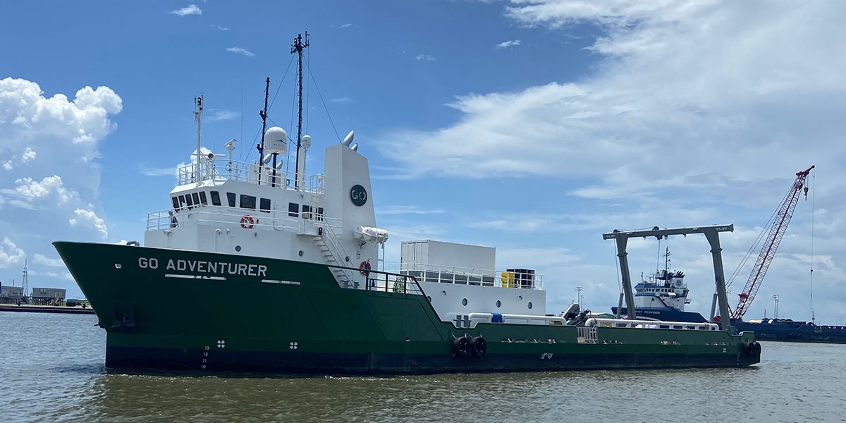
GO Adventurer
The company is bringing in a versatile research vessel to do the work, which will be done using underwater robots.
GSW has hired the GO Adventurer, a 205-foot long and 46-foot wide steel-hulled research ship owned by Guice Offshore that sports a 15-ton deck winch with A-frame on the stern.
The GO Adventurer will use Port Hueneme in Ventura County as a base of operations during the testing, the company said. Protecting the environment is a big part of these tests.
“Vessel crew and all aboard,” the news release said, “will follow strict mitigation measures to protect marine life and local ecosystems, including limiting vessel speeds to 10 knots and maintaining a 500-meter or greater separation distance from any sighted marine mammal.
“Trained Protected Species Observers will be aboard to identify and protect marine wildlife. A visual monitoring program will require survey zones to be cleared before equipment use, and there will be shutdown of equipment upon detection of Endangered Species Act (ESA)-listed whale species within or entering a pre-determined protective zone.”
As for marine mammals that the ship might encounter, California gray whales are at the tail end of their northern migration to Alaska from Baja, Mexico; and northern elephant seals are another marine behemoth that might be foundin local waters and could be encountered during the testing.
“The GSW team is committed to establishing meaningful and frequent engagement with all local stakeholders and those deeply connected to the region’s coastal lands and waters,” GSW CEO Tyler Studds said. “In addition to the Local Notice to Mariners issued through the U.S. Coast Guard, the GSW website [goldenstatewind.com] has been updatedwith information specific to mariners, including Frequently Asked Questions and Fisheries Communication Plan.
“The FCP details GSW’s plans for timely outreach, engagement, discussion, and collaboration with fishing communities and is a living document, which will continue to evolve with regular feedback and guidance from the fishing community, fishing organizations, regulatory agencies, and individual fishermen during all stages of our proposed project.”
The GO Adventurer was chosen for its versatility. “She is ideally suited for the government, research, subsea/diving andoffshore wind sectors, to name but a few,” reads the company’s website (guiceoffshore.com/fleet/go-adventurer).
What tests?
These tests will determine what lays below in the Call Area, where the waters run from 800-1,300 meters deep (2,400-4,200 feet), with the idea to avoid high-value areas like rocky reefs and sea mounts.
“Geophysical surveys are non-invasive and use low-energy equipment to map features on the surface of the seafloorand the geological layers beneath it,” Crawford said. “GSW surveys will [primarily] be conducted using autonomous underwater vehicles [AUV]. Survey data will reveal potentially sensitive resources and allow for avoidance of those natural features and to assist in thoughtful project siting and planning.”
With a stated goal of building 1 gigawatt of capacity in each of three lease areas, the GSW Project could have hundreds of turbines, depending on the generating capacity of each one.
Currently, the largest turbines run some 14 megawatts each (10 MW used to be the standard in 2016, when this whole idea was first hatched).
It’s been reported that each turbine will need about a square mile of space. The lease areas run around 80,000 acres each. Six hundred and forty acres equals a square mile, and at 80,000 acres, it’s possible to have as many as 125 turbines in each site, as per the space available.
The testing and mapping of the seafloor will go a long way in determining where and how many turbines go in.
“GSW will employ survey data for engineering and permitting a proposed offshore wind energy installation, ensuring project designs that avoid and minimize potential impacts by reducing physical and biological disturbance of marine resources and wildlife,” Studds added. “Low-energy geophysical survey technology used in offshore wind is very different from seismic air guns used in oil and gas surveys and sonar used in tactical military operations emitting lower noise at higher frequency and narrower beam width.”
Equinor tests continue
Another of the companies, Equinor, began doing essentially these same tests on its lease area in May and continues with that work now, though there have been some delays due to rough sea conditions.
It had also been prepared to go to the Coastal Commission in May for a Coastal Development Permit, and the executive director had decided to issue a waiver.
But the company pulled it from consideration before the meeting and announced it planned to skip the waiver, apply for a full CDP and navigate the commission’s normal permitting process.
Essentially, the commission’s executive director had relied on previous determinations by the State Lands Commission that said no environmental impacts would result from such sound tests.
Fishermen Sue
Meanwhile, local commercial fishing organizations in Morro Bay and Port San Luis filed a lawsuit to try and stop the testing before it started, claiming it would change the environment and that the testing work was moving forward without several legal requirements first being met.
They had a hearing on their request for an injunction to stop the work to allow the lawsuit to work its way through the courts. The judge did not grant the injunction but also didn’t outright throw the lawsuit out, which was a small victory for the fishermen. A judicial decision is expected soon.
Tests continue
Equinor continues its underwater testing at the Call Area, moving back and forth and back and forth, in its lease area, plotting every single tow of the underwater equipment on computer.
In its June 14 “Notice to Mariners,” Atlas Wind said, “The OSV Island Pride [the vessel doing their deep water surveys] is on weather stand by and seeking shelter in Morro Bay. Island Pride will return to location of the northern lease area when weather permits.”
Island Pride “placed underwater transponder positioning devices [UTPs] within the Atlas Wind lease area. These are small devices that sit on the seafloor and aid with positioning of the autonomous underwater vehicles [AUVs] that areconducting the geophysical surveys. They reach approximately 12 feet above the seafloor and are at depths greater than 3,000 feet.
“The UTPs will be completely removed after surveys are completed in the area. These small devices are placed in a grid pattern that is approximately 3.75 miles by 3.75 miles, so they are spaced far apart.”
The main goal is to try and avoid getting fishing gear tangled up with one of the device, and Atlas Wind posted a link to a claim form on the project website. They also want to avoid any incidents with transiting boats and the research vessel.
They plan to start monitoring the sounds in the area too, documenting the wildlife, according to the Notice to Mariners.
“Atlas Wind will also be installing passive acoustic monitoring devices on the OSV Island Pride to detect and record bird and bat calls,” it said. “These devices do not emit any sounds. They are small microphones on the vessel that will record potential bird and bat calls, which will later be analyzed to determine what species may be present.”
The impact to seabirds is a big concern for some opposition groups, just as it is with land-based wind turbines. Bird strikes have been recorded at wind farms on land, as the giant fan blades spin some 175 mph at the outer tips, fast enough to knock a bird out of the sky.
GSW said its testing will be done according to environmental guidelines and laws.
The company said it’s working hard to be a good neighbor.
“GSW project team members began meeting with Morro Bay and Port San Luis Commercial Fishing associations in July 2022,” Crawford’s release said. “Outreach has since expanded north and south of the Morro Bay region to be inclusive of commercial and recreational fisheries in and around the Morro Bay Wind Energy Area.
“Additionally, GSW has engaged with local Native American Tribal Groups to incorporate their concerns on the survey approach and posted a Native American Tribal Communications Plan to its website.”
Feature Image: The ocean research vessel, GO-Adventurer, was hired by the offshore floating wind company, Golden State Wind, to conduct underwater sound mapping of the seafloor in the so-called Morro Bay Call Area. That’s where GSW plans to install floating wind turbines. Photo courtesy Guice Offshore


